HMS
Repulse
(RN
Diving Magazine Vol 12 No 3 (Winter 1965) pp
39-41)
DURING May this year
[1965],
the Far East Clearance Diving Team had the very great and possibly unique
privilege of carrying out a brief diving survey on H.M.S. Repulse.
Approval for this
operation was granted on the grounds that it would be good training value as
well as being of unusual interest. Although Repulse is not officially
designated as a War Grave it is regarded as such and stress was placed on
the requirement that the ship was not to be entered and nothing was to be
disturbed externally. This trust was faithfully observed.
H.M.S. Repulse lies
some 45 miles N.N.E. of the
The location of this
datum marker by H.M.S. Barfoil (acting as Diving Support Ship) and M.F.V.
164 (with the Diving Team embarked) was initially thwarted by rough seas and
heavy rain and it was feared that the marker might have dragged well clear
of the wreck or even have sunk.
Fortunately H.M.S.
Ajax was in the area on her way back from
Diving conditions,
generally, were excellent. The water was very clear and, needless to say,
warm. In fact, underwater visibility was so good that the silvery shape of
Repulse could be seen from the surface of the sea through a face-mask,
before the sun rose too high and veiled her with the increased reflection
from the mass of particles in the water.
Those that claim to
have seen Repulse from the air and to have clearly seen her mast are
mistaken and have in fact seen the shadow area cast by the bulge keel. For
this majestic and awe-inspiring ship lies on the sea-bed almost completely
capsized to port with her starboard bilge keel uppermost and her decks
under-hanging the horizontal by about 30 degrees. She lies in a mean depth
of 180 feet with the stern in slightly deeper water of 196 feet, perhaps
caused by a tidal scour created over the years by prevailing ocean currents.
The bows lie in a heading of 196 degrees (true) which, were one to extend it
on a map, ironically passes through Singapore from whence this magnificent
ship set out on her ill-fated mission 24 years ago this December.
The hull is in very
good condition with remarkably little marine growth other than a scattering
of sea eggs, a few anemones and small clams about 8 inches across. On the
wooden decks, which are bleached white and have lost their caulking, hang a
mass of oysters. Fish life abounds and the first customers normally seen on
the way down were large shoals of barracuda, static and staring with those
big beady eyes. Highly coloured angel fish and parrot fish were always
present around the wreck and also, occasionally, larger and more fearsome
inhabitants in the form of big grouper (or Jew fish) over 6 feet long, twice
as broad as the average man, and having a viciously spiked long dorsal fin.
These parochial creatures were given a wide berth, needless to say.
The only sign of
action damage was a large jagged hole some 20 feel aft of and slightly above
the starboard bilge keel from which twisted pipes and machinery grotesquely
protruded. The theory put forward that the 15 inch turrets fell out when the
ship capsized is certainly not so in the case of `Y' turret, which was seen
to be properly in place and trained aft.
It was our intention, had Repulse been upright and her mast intact, to replace her battle ensign prior to leaving the area. As this was not possible, a mast was made up of a 60 foot span of dan wire supported by three elliptical floats instead and this was `keel hauled' into position and secured to its own part round a propeller shaft. From this `mast' and immediately below it was sewn a six breadths White Ensign which was last seen proudly billowing out in the tide.
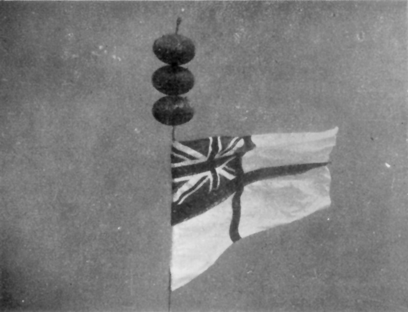
White Ensign secured to one of
HMS Repulse's propeller shafts
D.P.R.L.
[Lt Cdr David
‘Ginger’ Lermitte RN, CO
HMS
Prince of Wales
(RN
Diving Magazine Vol 14 No 1 (Spring 1967) pp
10-11)
NEARLY 25 years ago,
on December 10th, 1941, H.M. Ships Repulse and Prince of Wales were sunk
within an hour of each other by Japanese high level and torpedo bombers some
45 miles N.N.E. of the island of Pulau Tioman, off the East Coast of Malaya.
Repulse was the first to sink at 1233 as a result of five torpedo and one
bomb hits. The Prince of Wales followed at 1320 having sustained five or six
torpedo hits (two port side aft, followed by three or four forward, midships
and starboard side aft) and one bomb hit.
Both ships heeled over
and capsized to port on sinking, with the Repulse proceeding at
approximately 15 knots, but the Prince of Wales reduced to less than 8
knots. The ships have come to rest with the Repulse lying in a depth of 180
feet and the Prince of Wales 8 miles away to eastward in a depth of 216
feet.
In May 1965, the Far
East Clearance Diving Team carried out a brief external survey of H.M.S.
Repulse and an article on this diving operation was published in Volume 12,
No. 3 of this Magazine.
This year [1966] we have done
a similar survey of the Prince of Wales, and you might be interested to read
this short account of the operation.
The Prince of Wales
was located on Sonar and marked with two mooring buoys prior to the start of
the operation.
The Far East Clearance
Diving Team backed up by Clearance Divers from H.M.S. Sheraton, and the
Royal Australian Navy's C.D.T. 1, carried out the survey, involving six days
on task, between April 25th and May 6th 1966. Diving was initially carried
out from H.M.S. Sheraton, but halfway through the operation, she had to be
withdrawn for another task, and the team transferred to H.M.S. Barfoil for
the remainder of the operation.
A total of 64 dives
were carried out between 160 and 180 feet involving an overall underwater
time of 33 hours. Most of the dives were carried out in S.D.D.E., [Surface
Demand Diving Equipment] but S.A.B.A. [Swimmer’s Air Breathing Apparatus]
was used on a few occasions, particularly for the towed diver searches from
the Gemini Dinghy. The weather was fine but the ocean current, although not
strong, was unpredictable and at times hindered the operation by making the
positioning of the diving support ship above the wreck difficult.
The Prince of Wales
lies on a heading of 020° and, bar about 50° or 20°, is completely capsized.
The shallowest part of the ship is in the vicinity of her starboard bilge
keel at a depth of 150 feet. The large flat expanse of the ship's bottom is
remarkably free of marine growth and apart from the occasional sea egg, weed
or small clam, is only covered with a fine layer of silt. However, the
vertical surfaces and those in the dark under-hanging part of the ship are
well covered with small clams, weed and similar encrustation.
Owing to the vast size
of this ship and the problems concerned with mooring the diving support ship
above her, it was only possible, in the limited time available, to dive on
three separate zones of the Prince of' Wales, namely, amidships in the
vicinity of the engine room, right forward on the stem and the right aft in
the vicinity of the propellers and rudders.
During the course of
the survey the following evidence of war damage was seen:
(a) A large jagged hole about 20 feet in
diameter in the forepeak passing right through the ship and in one place
fracturing the stem post.
(b) The starboard outer shaft crosses over
the starboard inner and its propeller is wedged between the inner shaft and
the hull. There is a jagged hole some 6 feet in diameter slightly forward of
where the two shafts cross over.
(c) The port outer propeller is missing
entirely and the bare shaft has pulled away from the ship snapping the
A-bracket in the process. A few feet forward of the A-bracket stub
is a large hole about 12 feet in diameter with
the shipside plating jaggedly bent inwards.
Diving conditions were
generally good, with at best a maximum horizontal visibility of 40 feet on
the wreck, but this would reduce to some 15 feet when the ocean currents
stirred up the silt. The wreck abounds with marine life and one was
constantly accompanied by shoals of fish of all varieties. Apart from one
very large and lethargic whale shark, no other kinds of shark were seen, but
large shoals of barracuda were frequently in attendance and on a few
occasions, large grouper or Jew fish were sighted.
As one ascends away
from the wreck and out of the then milky blanket that enshrouds this great
ship in her rest, one comes into crystal clear water with visibility in
excess of 120 feet. As you look down on this awesome sight, the full effect
of the tragic saga becomes very near to one in the quiet of the underwater
world.
D.P.R.L.
[Lt Cdr David
‘Ginger’ Lermitte RN, CO